Ridge Route 400km BrevetWe ride one, two, or three loops out of Santa Clarita, featuring the incredible "Ridge Route," Angeles Crest Hwy, Mt. Wilson, a dozen different canyons and much more.
 "I'm looking forward to finishing your brevet series this year. I had a fantastic time last year and learned a lot. The Ridge Route event still counts as the most wonderful ride of my life. I've been trying to get some club members to join me this year, but they all think I'm insane, so no dice there. I have a new ti bike and I've lost 20lbs so I'm raring to go." -Terry Hutt "This was truly an adventure. Your gamble on the Ridge Route paid off. This ride will offer a challenge to anyone, including of course to Mr. AdventureCorps himself." -Peter Penguin Pop "The AdventureCORPS Southern California Brevet Series introduced local riders to a new randoneering experience with a series best described as a trial by fire. Surprisingly tough for brevets, these are uniquely challenging rides. Tough, scenic, and barely a junk mile in the bunch. These 250 miles seemed tougher than any 300-mile stretch of the Furnace Creek 508 race. The 400K brevet applied the lessons learned in the previous two brevets: prepare well; it gets dark, it gets cold, eat, drink, keep the bike moving." -Perry Swan Smith InformationSTART/FINISH LOCATION START TIME CHECK IN COURSE CLOSES TWILIGHT ROUTE DESCRIPTION
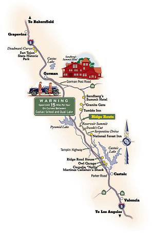
There is no "lowland double century" offered. Read on for the details. Keeping in mind that the hotel, and thus the start/finish for each loop, is at 1240' elevation, here's the description: Loop One heads north along I-5, then does a little warmup loop in Chiquito and Hasley Canyons near CA126 before it continues to Castaic. Here, after 14 miles, the climbing begins. We'll head northbound on the appropriately named Ridge Route, climbing higher and higher into ever more beautiful and remote territory up above I-5. After crossing Templin Highway at elev 2960, we'll have an 18 mile "epic adventure" as the Ridge Route becomes an "unmaintained road." Don't freak out, though: it's easily doable on a standard road bike. (And it's as true here as everywhere else that 19mm tyres are a bad idea.) We'll climb about 500', then roll along through an incredible set of rolling hills that vary between 3400' and 4000'. A few patches are very ripped up, some are gravelly, a few are hard-packed dirt, but 95% of this stretch is perfectly fine. The other 5% is never scary or dangerous. When scouting the route in 2001, I drove this at full speed in my low-to-the-ground Saturn SL2, then rode it on my Kestrel with 28 hole wheels and 23mm tyres. I had no problems, just lots of fun! (I think only one rider in 2001 flatted during the event.) At the top is the checkpoint and incredible views of California Poppies in the surrounding gone-back-in-time valleys. At this point you'll have done 4485' of cumulative elevation gain. From here we head east on Pine Canyon Rd and Three Points Rd, then south on Lake Hughes Road where we'll have a checkpoint around mile 70. Finally, it's a quick shot back to Santa Clarita along The Old Road. Fun! First Loop Stats: 14 miles mostly flat, then 26 miles mostly up and rolling, then 19 miles rolling, then 30 miles downhill and flat. 88 mile total distance with 7500' of cumulative elevation gain. Loop Two: Note that only brevet riders may choose the Lowland Loop Two. (Double riders who take the Lowland Loop Two will be listed as DNF on the results.) Highland Loop Two, with Support, for ALL Double Riders plus Highland 400km riders: This classic route heads south along I-5 on The Old Road, San Fernando Rd, then over to Foothill Blvd to traverse the eastern end of the San Fernando Valley, along the base of the San Gabriel Mountains. After an easy, downhill or flat 23 mile urban sprawl stretch to Sunland, we climb up Big Tujunga Canyon. This climbs 2,000' over 13 miles up to Angeles Forest Hwy. Then we go right 4 miles to Angeles Crest Highway at elev 3800'. Next it's left and across 4.6 miles to the checkpoint at the Mt. Wilson turnoff at elev. 4780'. All of these miles are just phenomenal, breathtaking, and quiet. From here, new for 2003, we'll ride up to the top of Mt. Wilson and back, a five mile ascent of 1000', then turn around and bomb back down those five miles. (There will be a system in place for riders to "prove" that they did, indeed, summit Mt. Wilson.) You're going to love this route! This will be especially true after rejoining Angeles Crest Highway and cruising another 4.3 miles to the Upper Big Tujunga where you get your another downhill treat: 9 fantastic, fast, downhill miles! Next is the final climb of this loop, a 6.3 mile, 1500' climb with a checkpoint at the top, but what follows is incredible! From here, at mile 74.5, it's all downhill or flat back to Valencia! We kid you not! You'll only climb 300 more feet in the last 48 miles of this loop! So, enjoy the fast ride down Soledad Canyon and get back to Santa Clarita before sunset! Highland Loop Two Stats: 25 miles flat, then 17 miles up and rolling, then five miles up and five miles down, then four miles up, then 9 miles downhill, then 6 miles up, then 48 miles downhill or flat. 113 mile distance with 9500' of cumulative elevation gain. Lowland Loop Two, with Absolutely No Support for 400km riders ONLY: This alternative second loop was designed for the 400km riders who want to avoid a chunk of the overall climbing on this event, but still get in their miles, or kilometers, while self-supporting themselves. It does not count for the California Triple Crown, but it does count for the Planet Ultra Grand Slam and PBP Qualification. Riders will cruise completely on their own with No Support of Any Kind, from Santa Clarita, elevation 1300', to the coast at Ventura, elevation 50', then return to Valencia. It's mostly an out-and-back via Santa Paula, but riders use South Mountain Road on the way out and do a small loop in Ventura, too, in order to see a little bit more scenery. The checkpoint at Ventura and this entire loop are unsupported. Riders will stop at a specific hotel and get a business card to prove that they got there. Numerous stores and all-night mini-marts along the way can be used for resupply. Again, this option was created for hardy, self-supported, self-navigating 400km brevet riders only. Lowland Loop Two Stats: Basically 103 miles flat, with about 1500' of total elevation gain. To point out the obvious, it's slightly downhill from Santa Clarita to Ventura, then slightly uphill on the way back. This is a fast, straight-forward route. Loop Three is located between the first and second mountain loops, geographically speaking. It's also the shortest of the three loops and really quite easy, especially since we deleted eight of its miles as compared to previous years. It's also quiet and remote, making for good night riding. We head northeast out of Valencia on Bouquet Canyon, which is basically five flat miles, then we do about 18 miles of very easy, rolling climbing. Then it's a left up and down Spunky Canyon Road and across to the tiny hamlet of Green Canyon on San Francisquito Canyon. After a few flat miles, there's a short climb up as we continue "down" San Francisquito Canyon back to the start/finish in Valencia. Third Loop Stats: 7 pretty flat miles, then 19 easy climbing miles, then 21 mostly flat or downhill miles with one tiny climb near the end. 49 mile distance with a mere 3300' of cumulative elevation gain. Total Distance, utilizing Highand Loop Two: 250 miles with 20,300' of cumulative elevation gain. Canyons visited, in order, include: Chiquito, Hasley, Pine, Elizabeth Lake, Gavin, Big Tujunga, Upper Big Tujunga, Aliso, Soledad, Bouquet, and San Francisquito! Total Distance, utilizing Lowland Loop Two: 240 miles with 12,300' of cumulative elevation gain. Canyons visited, in order, include: Chiquito, Hasley, Pine, Elizabeth Lake, Bouquet, and San Francisquito! 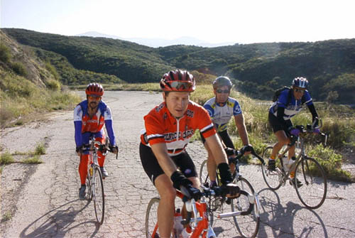
L-R: Paul Sparrow Hawk Byron, Chris Kostman, Mike Miller, and Peter Penguin Pop Slideshows, Reports and Results
Learn more about the Ridge RouteArticle from the Auto Club West Ways Magazine "Virtual Tour of the Ridge Route" "The website dedicated to that curvy little road that united California" |
|||||||||||
 |
 |

