Mount Laguna Bicycle Classic Route Description
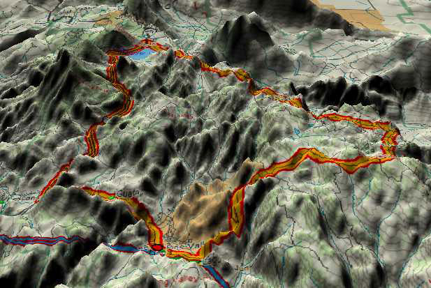
All 2D color maps, 3D graphics, and elevation profiles by Doug Dog Sloan
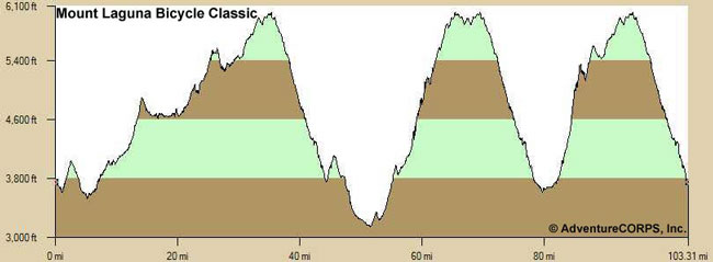
This incredible event features three loops that all begin and end in or near Pine Valley, CA. The total distance is 101 miles with over 10,000 feet of elevation gain. Click here for a seven-minute video slideshow of the entire route from start to finish. It is compiled from 181 images of the route from various rides we've enjoyed out there in recent years. The images are in sequential order, exactly as if riding the event. Each of the three loops is also depicted with a map, elevation profile, and 3D image. Turn up your speakers to enjoy the music! Click here to see a traditional slideshow of the entire route from start to finish. Features the same 181 images from the video slideshow linked above. Click here to see photos, plus the results, report, and feedback, from the Official Pre-Ride of the event, held on November 14, 2009. Click here to see photos, videos, and more from numerous cycling adventures we've had on and around Mt. Laguna over the past few years. It's a spectacular place! Here is the elevation profile for the full event:
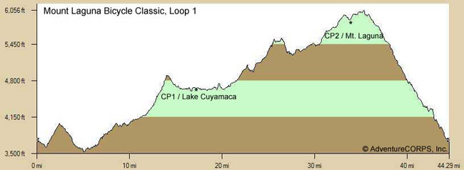
Loop One, depicted in the following three images, is a clockwise route from Pine Valley to Guatay, north on 79, around Lake Cuyamaca, and south on Sunrise Hwy over Mt. Laguna. (It does not quite return to Pine Valley.) Distance: 43.4 miles; Elevation Gain: 3770 feet. See this loop on BikeRouteToaster.com.
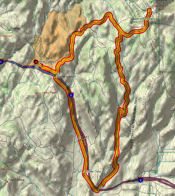
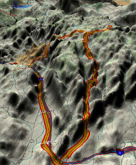
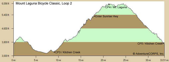
Loop Two, depicted in the following three images, is a counter-clockwise route from Sunrise Hwy east on Old Hwy 80, north on Kitchen Creek (which is closed to cars for 3.7 miles in the middle), north on Sunrise Hwy to the Mt. Laguna summit, then south on Sunrise Hwy and back to Pine Valley. Distance: 33.6 miles; Elevation Gain: 3300 feet. See this loop on BikeRouteToaster.com.
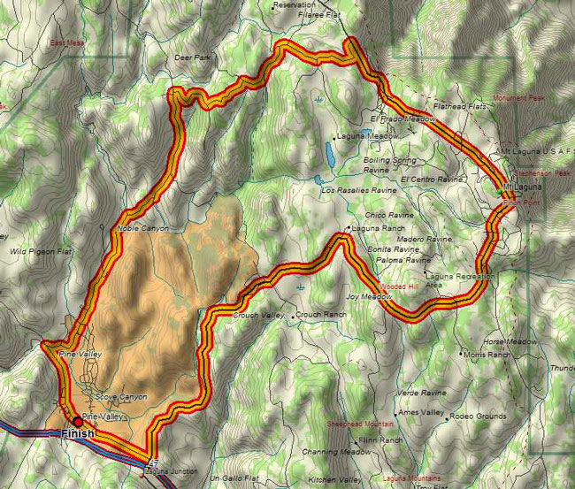
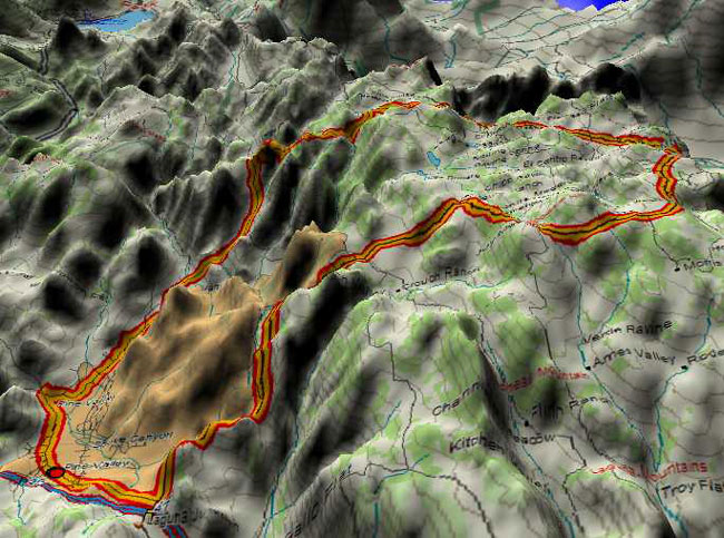
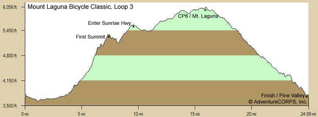
Loop Three, depicted in the following three images, is a clockwise route from Pine Valley, west on Old Hwy 80, then up the one-of-a-kind Pine Creek Road (as featured in the event logo) all the way to Sunrise Hwy, then south over Mt. Laguna and back to Pine Valley. Distance: 25.7 miles; Elevation Gain: 2820 feet (2000 feet of which is gained in the 10.2 miles on Pine Creek Road). See this loop on BikeRouteToaster.com.
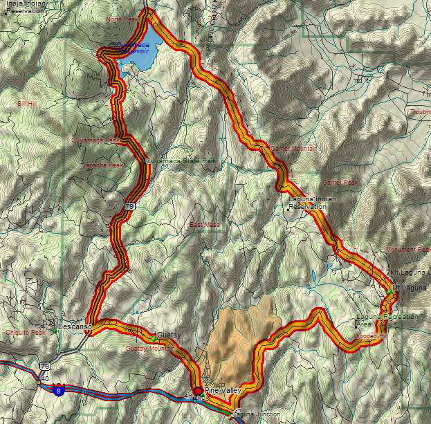
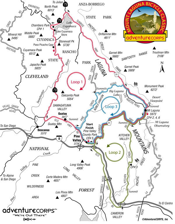
Below is the official Route Map which will be printed on the reverse of the Route Sheet given to each participant at check-in. This graphic was created by professional illustrator Bill Oetinger, who also created the event logo. More about Bill.
Click here for a seven-minute video slideshow of the entire route from start to finish. It is compiled from 181 images of the route from various rides we've enjoyed out there in recent years. The images are in sequential order, exactly as if riding the event. Each of the three loops is also depicted with a map, elevation profile, and 3D image. Turn up your speakers to enjoy the music! Click here to see a traditional slideshow of the entire route from start to finish. Features the same 181 images from the video slideshow linked above. Click here to see photos, plus the results, report, and feedback, from the Official Pre-Ride of the event, held on November 14, 2009. Click here to see photos, videos, and more from numerous cycling adventures we've had on and around Mt. Laguna over the past few years. It's a spectacular place! |
|
 |
 |